Tangram
Identificación de inestabilidades con control estructural
Cargando 0%
Centraliza y administra la información de la construcción de taludes de manera geoespacial y temporal, permitiendo gestionar el conocimiento adquirido durante la construcción de las paredes del rajo
TIMining SICT permite evaluar y dimensionar las desviaciones de los taludes construidos durante la implementación del diseño planificado, habilitando la gestión de iniciativas que busquen mejorar los ángulos de taludes en minería. El Sistema Integrado de Control de Taludes (SICT) Integra la metodología Full Control, lo cual facilita la identificación de elementos que inciden en logro del diseño planificado y la seguridad en mina.
TIMining SICT ofrece distintas herramientas al usuario, orientadas a facilitar el análisis y comprensión de los resultados de las evaluaciones, mediante vistas 3D, gráficos de control y estadísticas
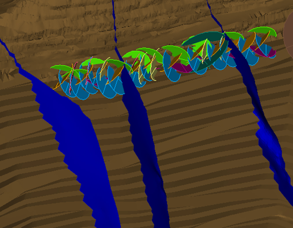
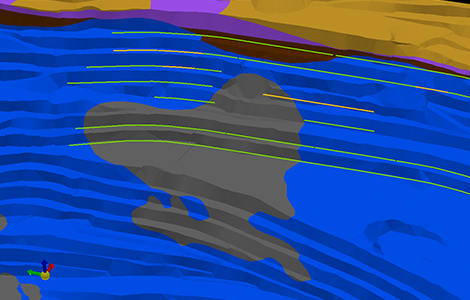
Permite evaluar el resultado geométrico del talud, a partir de la generación automática de un modelo geométrico empleado para conciliar la topografía del talud construido con el diseño planificado. Los usuarios pueden ajustar el modelo de forma asistida, adecuándolo a las condiciones de la mina
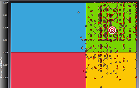
Permite gestionar el proceso de construcción de taludes a partir de métricas clave com lo son el logro geométrico (Factor de Diseño) y la condición geotécnica (Factor de Condición). El logro de estas métricas permite asegurar el éxito en la implementación del diseño del talud óptimo y la condición de seguridad en mina
Permite advertir oportunidades de mejora orientadas a la excelencia operacional y al mejoramiento de los ángulos de taludes. Los usuarios pueden analizar información de manera geoespacial y temporal (x, y, z, tiempo), mediante lo cual pueden aportar con antecedentes a la planificación e implementación del diseño de los taludes
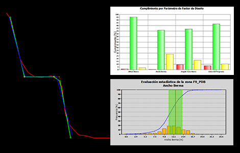
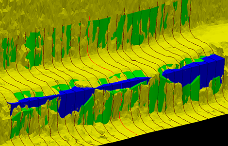
Permite realizar el seguimiento y control de los parámetros que componen la geometría de diseño banco-berma. Mediante el gráfico de Parámetros de Factor de Diseño, los usuarios pueden identificar de manera rápida y sencilla donde se están generando las desviaciones y en que orden de magnitud
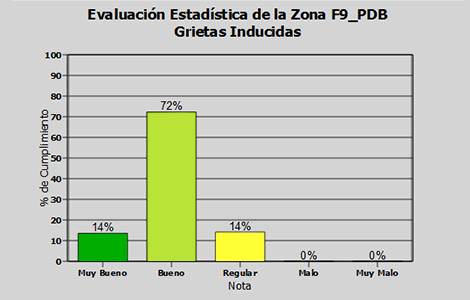
Permite realizar el seguimiento y control de la calidad geotécnica de los taludes, visualizando de manera gráfica los resultados de las evaluaciones de la condición geotécnica de los taludes construidos. Los usuarios pueden identificar fácilmente, cuáles son los parámetros que están siendo afectados por el proceso de construcción de taludes
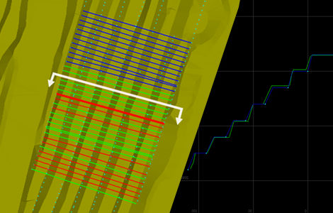
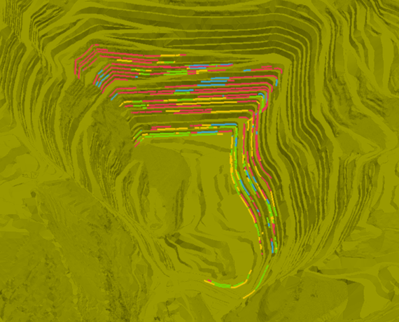
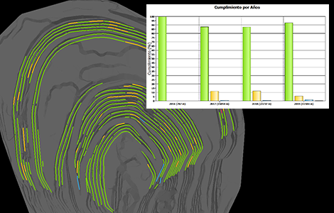
Permite realizar el seguimiento y control del ángulo interrampa a medida que se va construyendo el rajo. Los usuarios pueden generar un conjunto de secciones de manera automática para comparar y evaluar ángulo interrampa construido, frente al ángulo interrampa del diseño óptimo
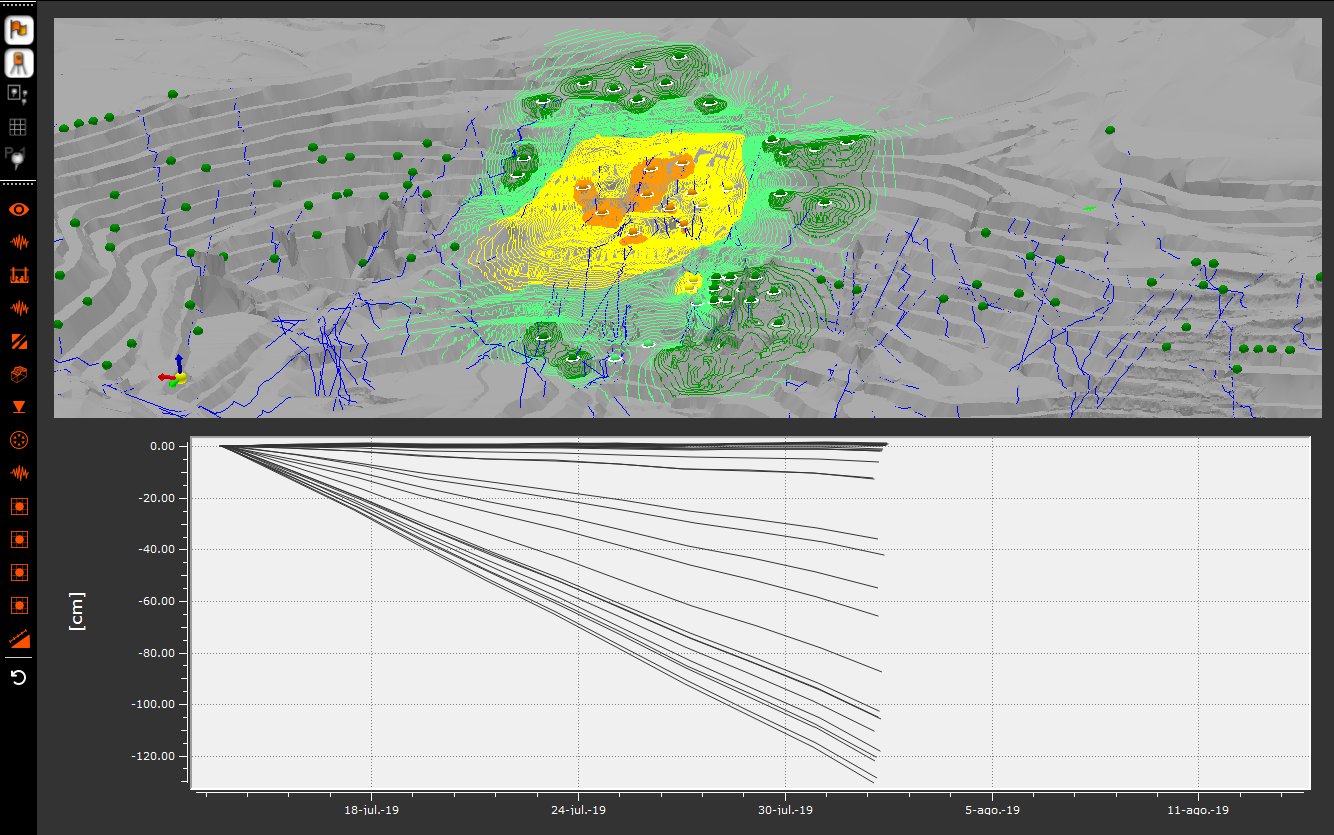
Permite correlacionar los resultados georreferenciados de la construcción de taludes con los distintos modelos 3D que disponga la compañía (geológico, geotécnico, estructural). A partir de este análisis, los usuarios pueden identificar de manera intuitiva, condiciones que han sido favorables o desfavorables para el proceso de construcción de taludes
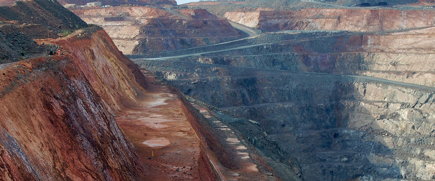
En primer lugar, SICT ofrece herramientas para un seguimiento y evaluación objetiva de la construcción del rajo, indicando cuando las prácticas de planificación y operación permiten cumplir con el diseño actual; que se supone satisface requerimientos económicos, de estabilidad y de seguridad. Así, cuando la evaluación es positiva, SICT entrega un respaldo claro para iniciar los estudios necesarios para evaluar un aumento de ángulo de taludes o las modificaciones que permitan mejorar el diseño minero y las prácticas operativas
El tiempo requerido para realizar una conciliación geométrica de la pared de un rajo dependerá de la extensión de esta. Sin embargo, TIMining SICT permite automatizar los procesos de creación de perfiles y administración de los datos medidos en cada perfil. Lo anterior, permite generar un ahorro en el tiempo de conciliación cercano al 70% del tiempo que requeriría realizar la conciliación de manera manual
Para realizar la conciliación geométrica con TIMinining SICT, la compañía necesita administrar la siguiente información:
- Polilíneas que componen el diseño del rajo banco a banco (patas y crestas)
- Superficie triangulada de la topografía real construida
- Parámetros de diseño del banco y ponderación considerada para el cálculo del Factor de Diseño
- Tolerancia de los parámetros de diseño de los bancos construidos
TIMining SICT posee una herramienta para gestionar tipos de geometrías de banco según las necesidades de cada compañía minera. Con esta herramienta se logran evaluar Bancos simples, bancos dobles en su etapa de construcción parcial y terminados, rampas y bermas de desacople
Si, el software permite configurar las tolerancias, pesos y métricas de evaluación del cumplimiento en función de las necesidades de la compañía
TIMining SICT cuenta con una interfaz diseñada para que los usuarios puedan digitalizar los registros del mapeo realizado en terreno. Además, es posible agregar registros fotográficos que sirven como respaldo histórico de la condición de los taludes
TIMining SICT dispone de diversas herramientas de análisis de la información que permiten obtener de manera sencilla vistas 3D y gráficos estadísticos de los resultados geométricos y geotécnicos de los taludes. Además, es posible identificar los elementos que afectan al logro geométrico (diseño planificado) y logro geotécnico (condición de seguridad minera) a través de la gestión de atributos de celda y tronadura
Si, TIMining SICT dispone de una interfaz en la cual los usuarios pueden crear nuevos atributos, habilitando la correlacionar estos nuevos atributos con el resultado de la construcción de los taludes
Para el funcionamiento de TIMining SICT, se necesita contar con una arquitectura cliente – servidor compuesta por el siguiente hardware:
- Un equipo para el almacenamiento y centralización de la información, pudiendo optar por un servidor (físico o virtual) o de manera análoga una estación de trabajo propiedad del cliente. El equipo servidor debe estar conectado a una red de comunicación de la mina
- Un computador personal para el uso de la aplicación cliente. Este equipo debe estar conectado a la red de comunicación de la mina
En general, al equipo servidor pueden conectarse un número ilimitado de aplicaciones cliente (monitor). La restricción podría darse por las características del hardware del usuario, el servidor o el ancho de banda de la red disponible para la conexión cliente – servidor
TIMining SICT no restringe ni limita la cantidad de información ingresada; más bien, dependerá de la capacidad de almacenamiento del servidor; lo que queda a criterio del cliente
Desde TIMining SICT se puede exportar lo siguiente:
- Gráficos y vistas 3D en formato JPG o PNG
- Tablas de datos de los resultados de la construcción de taludes
- Datos utilizados para realizar lo cálculos dentro del sistema en formato CSV
- Geometrías de los perfiles generados por el software en formato DXF
- Evaluaciones georreferenciadas de los taludes en formato DXF
Nuestra experiencia ha evidenciado que las compañías que han logrado el éxito en la implementación de TIMining SICT han realizado las siguientes iniciativas:
- Realizan gestión del cambio, relacionado con la administración y estandarización de los datos generados en el proceso de construcción de taludes
- Eliminan barreras que limiten del desempeño del usuario del software, incentivándolo a ejercer el rol de proveedor y/o analista de la información histórica del proceso de construcción de taludes
- Establecer metas que incentiven a mejorar los proceso involucrados en la construcción de taludes
Revisa nuestras diferentes soluciones de data analytics y simulación que ayudan a tomar mejores decisiones en Planificación, Geotecnia, Excelencia Operacional, y Operaciones Mina
Monitoreo del proceso de Perforación y Tronadura, QA/QC automático y conciliación de los planes de perforación.
Integración de monitoreo y vigilancia geotécnica para rajos, botaderos, pilas y tranque
 ×
×