Aris
Integración de monitoreo y vigilancia geotécnica para rajos, botaderos, pilas y tranque
Cargando 0%
Identificación de inestabilidades geotécnicas de forma automática y georreferenciada, a partir de las estructuras mapeadas en la faena y topografías de avance y de diseño
Tangram es un software que permite identificar inestabilidades de forma georreferenciada en topografías de avance y de diseño, indicando cuáles bloques son inestables. Esto se realiza a partir de los mapeos estructurales de la faena y las fallas modeladas como superficies, almacenados y gestionados desde el software.
TIMining Tangram realiza la detección automática de inestabilidades y el cálculo de su factor de seguridad y probabilidad de falla, para luego obtener la topografía resultante al retirar los bloques inestables. Estas funcionalidades poseen un diseño intuitivo y amigable, siendo Tangram una herramienta de fácil uso y apoyo rápido para el usuario
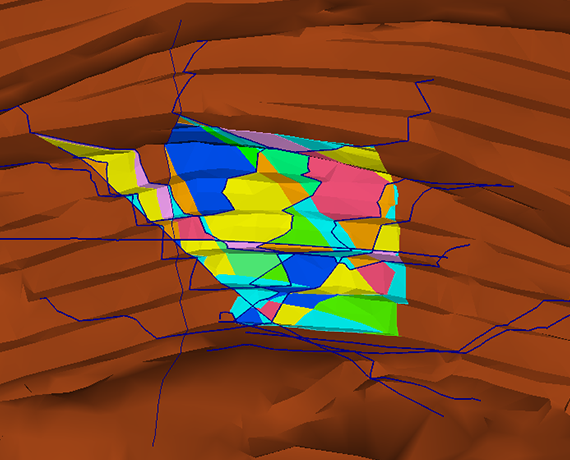
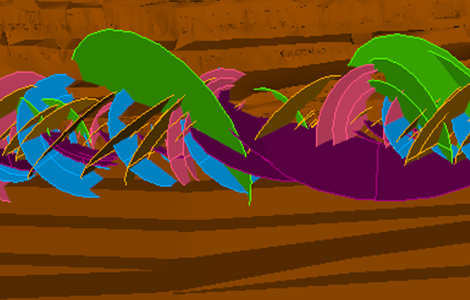
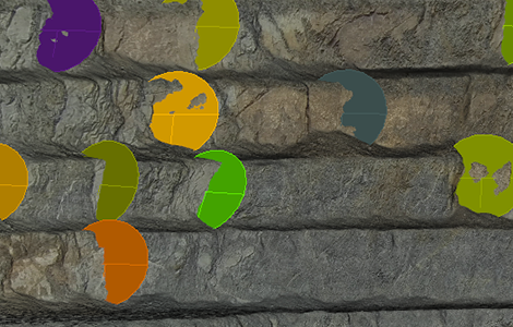
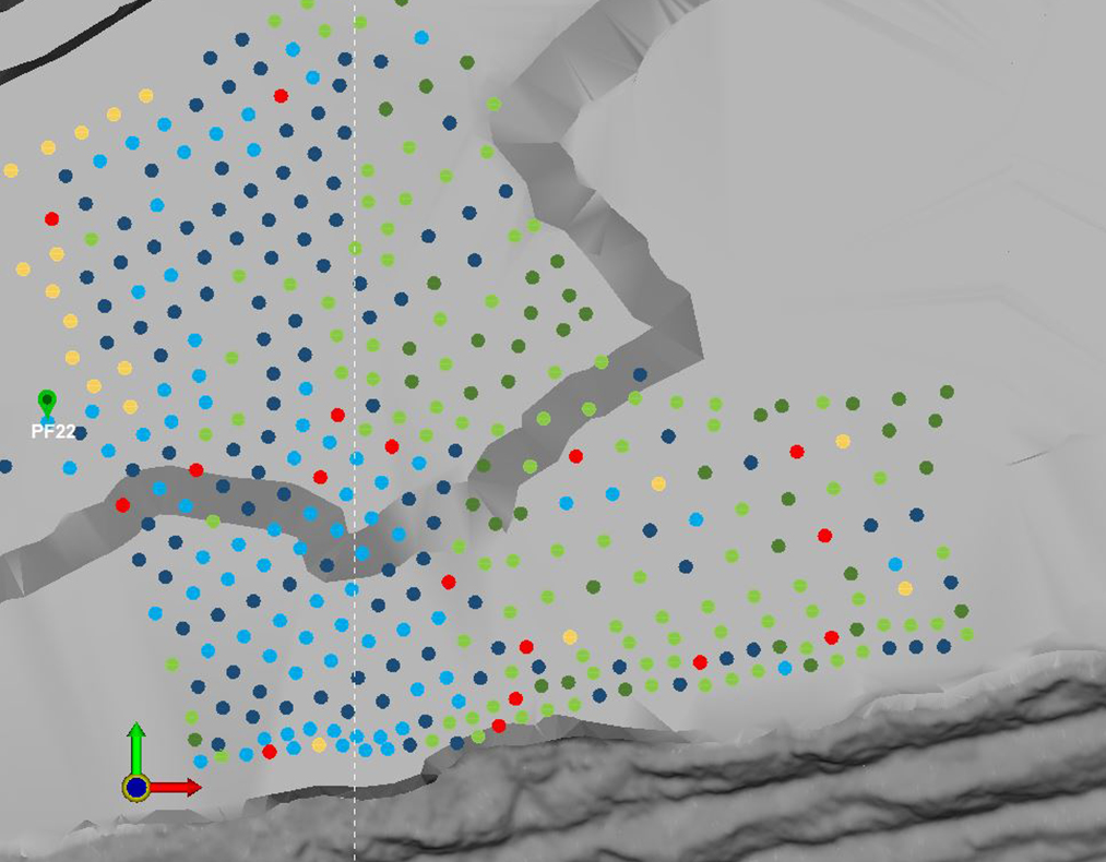
Tangram detecta de forma automática y georreferenciada potenciales inestabilidades formadas por las estructuras mapeadas en la faena. Se detectan tanto fallas planas y cuñas, como bloques complejos formados por 3 o más planos estructurales
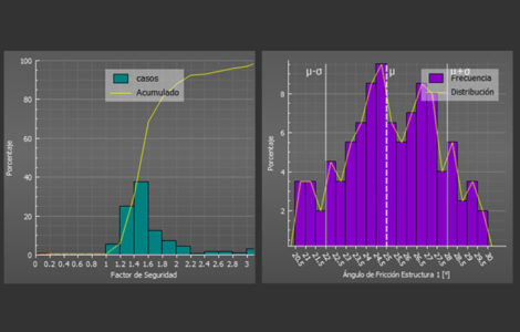
Para cada bloque encontrado sobre la topografía, Tangram calcula el factor de seguridad y probabilidad de falla. Luego, es posible filtrar y colorear los bloques de acuerdo a su factor de seguridad, probabilidad de falla u otras variables como volumen y tonelaje
Tangram permite modelar taludes para detectar inestabilidades variando parámetros como ángulo cara de banco, ancho de berma y altura de banco. Las inestabilidades detectadas en este talud o en topografías de avance y de diseño, pueden ser extraídas obteniendo una topografía resultante que simula cómo quedaría el talud una vez removidos los bloques inestables
Con Tangram es posible proyectar las estructuras mapeadas en el último banco hacia una topografía de diseño para evaluar predictivamente las inestabilidades que se formarán más adelante. También se pueden crear estructuras de forma aleatoria basadas en los sets estructurales de la faena, poblando una topografía de diseño con estructuras simuladas
Tangram permite cargar imágenes fotogramétricas de los taludes sobre la topografía, apoyando el mapeo estructural a distancia, sobretodo en zonas sin acceso. Sobre cada topografía se puede levantar estructuras y modelar nuevas superficies de falla
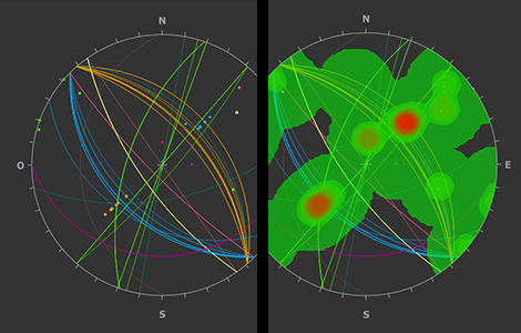
Con Tangram el usuario puede obtener las trazas de las estructuras sobre los taludes; visualizar las estructuras en una red estereográfica y seleccionar para asignar sistemas; triangular, dividir o componer topografías a partir de avance y diseño; visualizar secciones, perfiles y recortes; cargar modelos geológicos y geotécnicos
Los softwares RocPlane y Swedge permiten modelar solamente una falla plana o una cuña en un talud ideal. Tangram identifica todas las fallas planas, cuñas y también bloques formados por 3 estructuras o más, de forma georreferenciada, en una topografía real.
Leapfrog es un software de modelamiento geológico, en el cual se generan sólidos de litología, alteración y mineralización; y que permite modelar y mapear superficies de falla que modifican la disposición de estos cuerpos. Tangram permite modelar y mapear superficies de falla, ya que es un software orientado al área estructural, identificando las inestabilidades formadas por estas fallas y estructuras menores
Tangram identifica inestabilidades con su factor de seguridad asociado, lo cual permite decidir si serán retiradas banco a banco, o tomar decisiones enfocadas en la seguridad de la operación. Aumenta la continuidad operacional disminuyendo la cantidad de eventos geotécnicos con su identificación y predicción de inestabilidades, y permite analizar distinto diseños con diferentes ángulos de talud y anchos de berma, para acercarse a los parámetros óptimos para el negocio con menor cantidad de inestabilidades formadas.
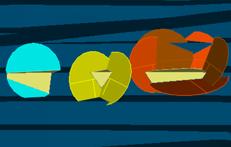
- Fallas planas: Tangram identifica las estructuras que intersectan la topografía, y evalúa la diferencia de azimut entre el talud y la estructura de acuerdo al límite ingresado por el usuario para la formación de una falla plana. Luego crea planos liberadores para formar la inestabilidad junto a la topografía.
- Cuñas y Bloques de 3 o más planos: Tangram intersecta todas las estructuras consideradas con la topografía, y muestra dónde se forman poliedros cerrados en conjunto con la topografía (poliedros aflorantes).
Sí, en Tangram se pueden crear nuevas estructuras mapeando sobre el talud.
Sí, Tangram recibe fotogrametrías conformadas por 3 tipos de archivos: una superficie, una o más imágenes que constituyen la textura de la superficie, y un archivo que conecta la textura con la superficie (.mtl).
Sí, Tangram permite crear discos en un talud de acuerdo a una distribución de dip, dip direction, espaciamiento y longitud, cada uno con media y desviación estándar asociadas, las cuales simulan las características del set estructural a representar.
Sí, en la identificación de inestabilidades Tangram puede utilizar como input tanto estructuras menores provenientes de una tabla de estructuras o csv, y fallas medianas y mayores modeladas como .dxf.
Para instalar Tangram y comenzar a utilizarlo solamente se necesita un notebook o computador personal, sin la necesidad de servidores y otras conexiones. La instalación se realiza con un archivo ejecutable en solo unos minutos.
Procesador: Intel 64 bit, Core i5 o superior. Recomendado Core i7
Memoria RAM: 6 GB mínimo. Recomendado 12 GB o más.
Disco duro: 250 GB mínimo. Recomendado 500 GB o más.
Sistema operativo: Windows XP (SP3) versión 64 bits o superior.
Gráficos: Tarjeta gráfica con soporte OpenGL 3.3, con 1 GB de memoria no compartida o más. Recomendado GeForce GTX 460 o superior.
Pantalla: Resolución mínima 1024 x 728
Periféricos: Mouse con rueda de desplazamiento
Revisa nuestras diferentes soluciones de data analytics y simulación que ayudan a tomar mejores decisiones en Planificación, Geotecnia, Excelencia Operacional, y Operaciones Mina
Integración de monitoreo y vigilancia geotécnica para rajos, botaderos, pilas y tranque
Monitoreo del proceso de Perforación y Tronadura, QA/QC automático y conciliación de los planes de perforación.
Aumenta el cumplimiento del plan y las velocidades promedio con el monitoreo de estos KPIs en tiempo real
 ×
×